-
Title
-
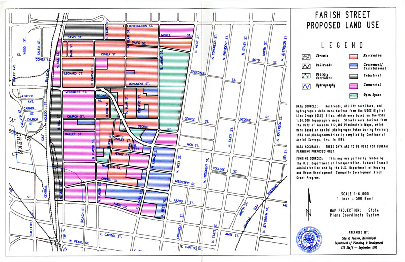
Farish Street Existing Land Use Map.
-
Date
-
1992-09
-
Description
-
A map of the Farish Street Historic District with markers for different land uses: streets, railroads, utility corridors, hydrography, residential, government/institutional, industrial, commercial, and open space.
-
Additional Subject
-
Architecture
-
Location
-
Farish Street Historic District
-
Jackson
-
Mississippi
-
Type
-
Map
-
Medium
-
Paper
-
Measurements
-
17 in x 11 in
-
Format
-
PDF
-
HBCU Identifier
-
mwchcac.oh.2022.fsp.photo3
-
HCAC Identifier
-
HCAC.JSU.0015
-
Rights
-
All rights held by the Margaret Walker Center. For permission to publish, distribute, or use this image for any other purpose, please contact Margaret Walker Center, Jackson State University, 601-979-3935 Attn: Center Director
-
Contributing Institution
-
Jackson State University
-
Source
-
Supplementary photograph collection with The Farish Street Project Oral History Collection
-
Language
-
English
-
About This Record
-
The HCAC public history focused digital archive cataloging is an ongoing process, and we may update this record as we conduct additional research and review. We welcome your comments and feedback if you have more information to share about an item featured on the site, please contact us at: HCAC-DigiTeam@si.edu


